Severe Weather Warning Issued for Lafayette County and Oxford
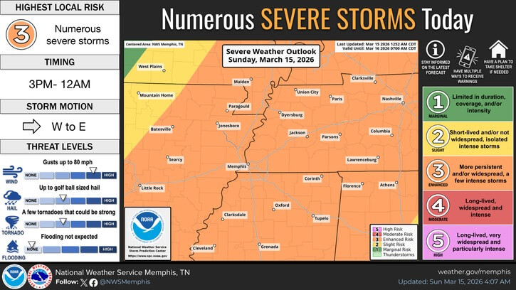
The National Weather Service in Memphis has issued an enhanced risk of severe thunderstorms for Lafayette County and Oxford on Sunday. The Level 3 of 5 threat includes damaging winds, tornadoes, and large hail, according to a weather alert.
Storms are expected to develop from west to east, beginning in western Lafayette County around 6 p.m. and moving across the area through midnight. The primary threat is damaging winds up to 80 mph, which could down trees, snap power lines, and cause structural damage. Tornadoes are also possible along the storm line with little warning. Large hail up to two inches in diameter may also occur, the weather service said.
A wind advisory is in effect until 7 a.m. Monday, with forecast gusts of 35 to 45 mph outside of storms. Residents are advised to secure outdoor items and stay alert. Officials recommend identifying shelter locations now, especially for mobile home residents, and enabling wireless emergency alerts on cell phones. People should also charge devices, have flashlights ready, and avoid driving through flooded roads.
After the storms pass, much colder air will follow. Oxford’s low temperatures are expected to drop to 31 degrees Fahrenheit Monday morning and 24 degrees Tuesday morning. Authorities urge residents to protect their homes, pets, and pipes from the cold. Updates will be posted throughout the day on social media and weather channels.
Source: Original Article